Aztalan Vortex
-
Vortex Type: Energy
Aztalan State Park is a Wisconsin state park located just south of the town of Aztalan, Wisconsin. Aztalan is the site of an ancient Mississippian culture settlement that flourished during the 10th to 13th centuries. The indigenous people constructed massive earthwork mounds for religious and political purposes.
-
Aztalan was first settled around 900 by a Native American culture known as the Middle Mississippian Tradition. The chief center of a Middle Mississippian settlement is at Cahokia, in present-day Illinois.
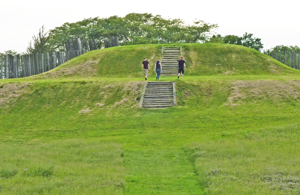
Three platform mounds remain on the site. The largest is the one in the southwest corner of the stockade; one almost as large is located in the northwest corner. The smallest of the three is along the east side of the settlement, near the Crawfish River (labeled "West Branch of Rock River" on the plates).
The hill in the southeast corner is a natural gravel knoll, not built by the inhabitants. The largest mound was built in three stages, with a set of steps leading to the top, where a structure was built over the entire flat top. The mound was covered with a clay cap, probably to enhance its appearance.
The northwestern mound, used for formal burial, was also built in three stages. A special structure, approximately 4 metres (13 ft) by 2 metres (6.6 ft), with its long axis towards the northeast/southwest, was built on the west side of the mound. Its doorway was in its southwest corner, and the structure was covered with a mixture of clay, willow branches, and grass. The floor was covered with a mat of what may have been cattails. The bodies of ten people were placed side by side on this, with their heads toward the doorway. The bones of another person were bundled together with cord and placed near them. Once this construction was complete, and the bodies were inside, the building was burned.
The eastern mound had a large open-walled structure, about 12 metres (39 ft) by 27 metres (89 ft), built on top of it, with firepits lined with white sand inside. The function of this mound and structure remain unclear. Additionally, to the northwest of the stockaded area, a row of round mounds extends northward. When archaeologists dug in these mounds during the 1920s, they did not find the burial sites they had expected. Instead, each mound had a large post set in a pit in its center, surrounded by gravel and soil, with the pit capped with clay and gravel to hold the post steady. These mounds have been termed "marker mounds" because they may have been used to mark the site for travelers, but this is not certain. They may also have been used for announcements, message relays, or for calculations of astronomical phenomena, as has been found at other Mississippian sites, such as Cahokia. - wikipedia
Resources
By James Steakley (Own work) [CC BY-SA 3.0 (http://creativecommons.org/licenses/by-sa/3.0) or GFDL (http://www.gnu.org/copyleft/fdl.html)], via Wikimedia Commons
Note: There is currently no scientific method to prove that vortexes exist. Just because a location is on the vortex map, does not prove there is a vortex there. What it means, is that someone suggested the location and provided evidence or a personal account, and/or we found corroborating evidence from other sources. We do this so other visitors to the site can send us their opinion on the validity of the vortex claim, to build a consensus.
Have you visited this location? If so, contact us and let us know if you think this place is a vortex or not. We will post your comments here.